

Rating:

Round Trip Distance: 2.3 miles
Difficulty: Easy
Elevation: 4726 - 4826 feet
Cellphone: 0 bars
Time: 1 hr. 30 mins.
Trailhead: Palatki Visitor Center
Fee: $5-1 day/vehicle or Interagency Pass
Attractions: Cliff dwellings, rock art
The Palatki Heritage Site is located in the Coconino (ko-kuh-NEE-no) National Forest near Sedona, Arizona. Palatki (pu-LAT-kee) means 'red house' in the Hopi language. The Palatki site consists of several Sinagua cliff dwellings as well as some extensive pictograph panels. Archaeologists believe that the cliff dwellings were built by the Sinagua beginning in 1125 CE and used until about 1300 CE.
NOTE: Only 10 people at a time are allowed to visit the site of the cliff dwellings. Groups depart every 20 minutes beginning at 9:40 am. Visitors should be sure to call the number (928) 282-3854 ahead of time to make a reservation. More information including seasonal closures is available on the Forest Service website.

Getting to the Visitor Center where the hike begins requires driving on 7 miles of dirt roads. You may find it handy to visit the Forest Service website and print out the directions to bring with you. If you use the Get Direction function of Google Maps it will probably route you through Dry Canyon and over Boyntan Pass which is an alternate but rougher route. Everyone must stop at the Visitor Center before entering the site. The quaint Visitor Center has a small gift shop where a very informative tour guides can be purchased.

After leaving the Visitor Center the trail splits with the right fork leading to the cliff dwellings and the left fork leading to the pictograph site. The towering mountains with their banded red rock sandstone make a beautiful background setting. The area east of the Visitor Center would have been where the Sinagua planted their crops of corn, squash, beans and cotton. Charles Willard, whose grandfather was on the Lewis and Clark Expedition, planted a large fruit orchard with over 5,000 trees here after homesteading the land in 1923.

The trail becomes a little more primitive as it climbs about 60 feet up to the east alcove.

A docent awaits each group that comes up to the alcove. The guide shares a wealth of information that has been gleaned by archaeologists that have studied the area and relates it in general to findings discovered at other sites. Besides the crumbling rooms of the dwelling visitors will be able to see a metate and mano that were used to grind seeds and the small cobs that once had corn upon them.
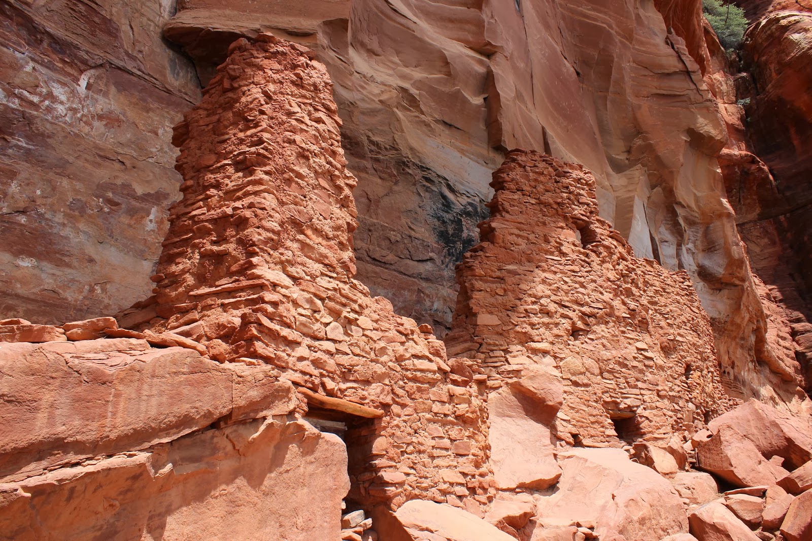
The East Alcove is a nine room structure where at least some rooms had a second story room above them. Glimpses of the West Alcove that had 5 to 7 rooms can also be seen from here.

A few unique pictographs can be seen painted on the side of the cliff.

This is a photo taken from the view area below the trail leading up to the alcove.

After hiking to the East Alcove visitors can head back toward the Visitor Center and take the other fork in the trail that leads to the grotto and pictograph sites.

The grotto is protected somewhat from some of the harshest elements of nature that may have otherwise made the already faint pictographs impossible to discern.

Most every usable space has something painted on it.

Not too many homes even today can boast a view as beautiful as this.

The east facing walls in the area of the grotto have an array of images, many of which, are unlike any of those found anywhere else.

There was also a guide, or docent as they refer to them here, in the rock art area to explain much of what could be seen there. These pictographs were originally painted in white. Heat from nearby fires caused soot to adhere to the fat used to make the paint resulting in their current appearance.

Judging from the variety of colors used I would guess that for their day the Sinagua had the big box of crayons.

What looks like another cliff dwelling is tucked away in an area close by that is off limits to visitors. This was built by Charles Willard as a temporary residence that he lived in between 1923-1925. What remains of the roof is supported by chicken wire that is attached to the cliff.

