Round Trip Distance: 0.5 miles
Difficulty: Moderate
Elevation: 5991 - 6077 feet
Cellphone: 0-2 bars
Time: 1 hr.
Trailhead: Carrot Men
Fee: none
Attractions: Barrier Canyon, Fremont and Ute petroglyphs and pictographs
The Carrot Men Site is number 16 on the Rangely Rock Art Tour near Rangely, Colorado. The site is listed as Moon Canyon on the National Register of Historic Places and is considered an important resource in the work of discovering more about the early inhabitants of Western Colorado. Signs of habitation date from the Archaic Period (3000 BCE - 100 CE) up to the Ute Period (1300+ CE).
The turnoff to the trailhead is at milepost 11.6 on the Rangely Dragon Road. Drive west on the Cottonwood Creek Road for just over a quarter mile and park at an unmarked turnout on the left side of the road.
The turnout serves as the trailhead. Look for a faint trail that leads down into the shallow wash.
Follow the wash down the drainage as it descends into the head of the canyon beneath some large alcoves.
All of the rock art panels are in the same general area of the cliff. Be sure to read the BLM's very informative sign that points out various elements with explanations of the rock art styles.
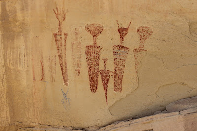
The red carrot men loom largest among the images. A close examination reveals that while the main portions of the carrot men were done with red iron ore pigments other colors are present, including green, blue and black, in places like their headdresses and body areas.
These blue images may have been done with azurite which is quite rare in this area. That might possibly signify trade with other people or distant travels.
There are some yellow Ute tepees that are very faint. The Ute didn't have tepees until after they acquired horses which was sometime after the Spaniards arrived on the continent.
As you can see from our Google map we explored more of the canyon than just the area around the carrot men. The only other thing we found of any interest was a geocache box that was stashed beneath a boulder.
Here you can see the turnout along the Cottonwood Creek Road a little better. I believe that if you drive the full 0.3 miles indicated on the sign you might pass up this spot by just a bit.
The Rangely Dragon Road continues south for about 7 miles to an intersection with the road that comes up Little Horse Draw. That road connects with Highway 139 providing an alternate route to take. There are steep sections with multiple switchbacks and travel should be limited to dry road conditions only.
The Little Horse Draw route takes more time but it covers more territory and there are more opportunities to see some of the areas many wild horses, deer and other game. Whichever route you take the Carrot Men Site is one of those destinations that is worth going out of your way to visit. If you would like to see it for yourself then all you have to do is 'Take a hike'.


