


Round Trip Distance: 1.2 miles
Difficulty: Moderate
Elevation: 2326 - 2423 feet
Cellphone: 0 bars
Time: 1 hrs. 30 mins.
Trailhead: Falling Man
Fee: none
Attractions: petroglyphs, scenic desert
The Falling Man Site is located in the Gold Butte National Monument near Mesquite, Nevada. Besides an interesting petroglyph that is located high up on a cliff above a small valley that depicts a 'falling man' the site boasts a dozen large panels of extensive petroglyphs as well as numerous other smaller panels. An occasional pictograph can also be found along with what appear to have been concentric circles in places where the surrounding rock features would cast their shadows for the purpose of tracking the seasons and other important events.

From Mesquite travel west on Nevada 170, the South Riverside Road, for about 9 miles and turn left onto the Gold Butte Road. Continue on this very memorable road of broken pavement for 19.7 miles and turn right onto the unmarked Black Butte Road. The road is dirt from here but might seem smoother than the paved Gold Butte Road. Follow the Black Butte Road for 1.9 miles to where the road passes through a fenced off area which is the trailhead. During good conditions most any vehicle with moderate ground clearance and a careful driver should be able to make it to the trailhead. Due to the 20 miles of broken pavement the vehicle of choice would be something like an ATV or side-by-side. Plenty of highway vehicles make the drive although at a much slower speed.

The trail starts off passing by domes, fins and outcrops of colorful sandstone along a pleasant avenue that is sparsely lined with beautiful joshua trees of various shapes and sizes.

Before going much more than 100 feet there are 2 large blocky looking masses of rock sitting atop a large mass of sandstone far off to the right of the trail where the first large panel of petroglyphs towers above the rest of the area.

At the 0.2 mile point from the trailhead a short side trail on the right leads into a small open area dominated by a large monolith known by some as Calvin's Rock that is covered with large numbers of petroglyphs both high and low upon its mostly east facing surfaces.

About 500 feet further along the main trail somewhat of a side canyon opens up on the right where the loop on our map begins. Here hikers have the option of climbing up to a tunnel that provides an adventurous route to the Falling Man petroglyph that can be found above a bench on the opposite side of the cliff. An alternate route that passes down a small gap can be followed that also leads around to the back of the cliff. Regardless of which route you take there are a few petroglyphs around the entrance of the tunnel that are worth examining.

This photo was taken after passing through the gap by taking the non tunnel route. From here it is an easy scramble up to the Falling Man petroglyph and another nearby panel. To continue around the loop to the wall panels drop over the south side of the saddle of the ridge.

The Falling Man seems to be holding a bright ball in his hand, maybe something like a star from the nights sky, which seems to convey more than just the simple idea of a man falling off a cliff. Then again, is he falling down or flying down? Did he reach too high for something (metaphorically) and fall?
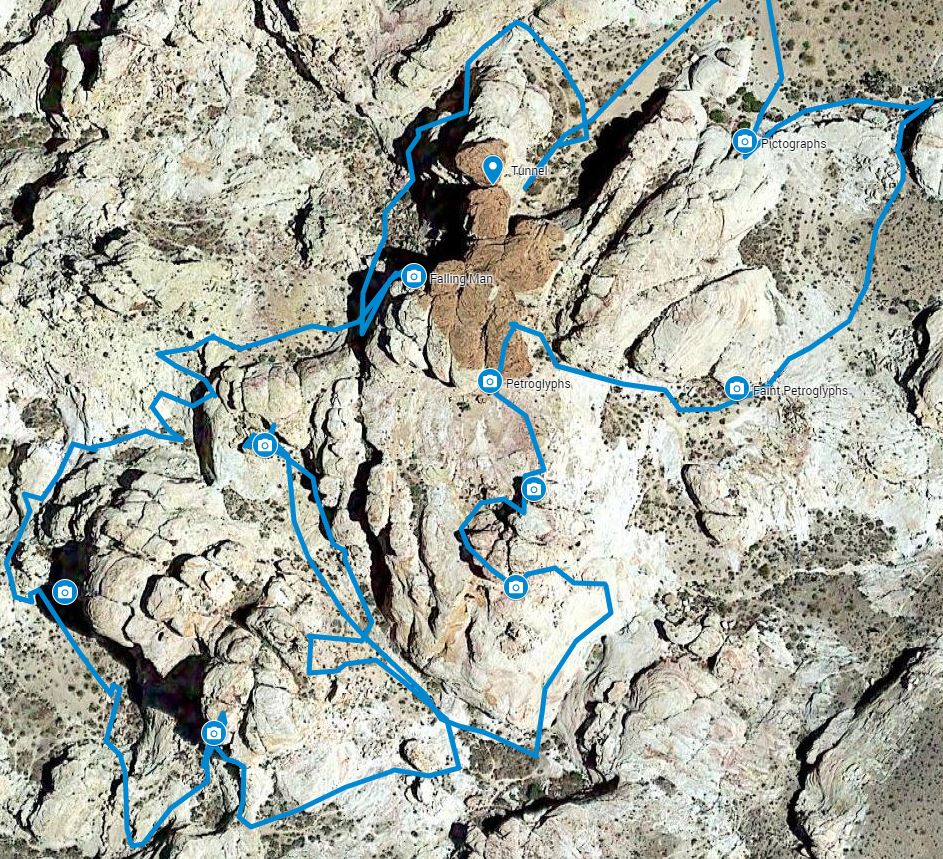
This satellite view of the loop might come in handy for route finding. The tunnel is in the reddish brown sandstone and each of the main panels are marked with camera icons. From Falling Man the route crosses to the south side of the saddle of the ridge where the sloping slickrock leads past another small panel. From there the route continues down and around the massive rock structure in the middle of the loop. As it rounds a southwest corner into the next open area there are some good petroglyphs on the cliffs. Heading southeast at this point the Wall Panels can be seen several levels higher up. A little hunting will find a suitable place to scramble up to the area just below the Wall Panels.

This is a photo of the largest of the Wall Panels. Out of the many images that are easily recognized are a rainbow. Among the images below the rainbow are a line of rain clouds. A man standing with his arms outstretched between 2 large stalks of what might be corn is similarly depicted in other nearby places.

There are a handful of other panels of various sizes on the same cliff or wall. This is one of the larger ones.

Scrambling over the ridge just to the right of the Wall Panels leads on around the loop to a long narrow upward sloping valley at the head of which the Newspaper Rock Panel can be found. Among the images on this large panel is another rainbow and a large paw print that looks like that of a grizzly bear.

From Newspaper Rock the route heads back down the narrow valley where it loops on around to the east. As it climbs up the slickrock there is another large panel on the point of a cliff much higher up. From this large panel you can hike around the west side of the prominence and find more petroglyphs. Across from these is the reddish brown sandstone of the same outcrop of the tunnel and Falling Man. The first noticeable petroglyph is a spiral but on around the cliff from that is another good panel. The pictographs in this photo are easy to miss. On the map they are labeled 'circles' and on the satellite view they are labeled 'faint petroglyphs'. There are some concentric circles along this cliff where overhangs and other protrusions cast shadows that change in relation to the circles as the position of the sun changes throughout the year. A few more pictographs can be found on a north facing cliff right before reaching the spot where the loop ends.

