Round Trip Distance: 2 miles
Difficulty: Strenuous
Elevation: 9193 - 9973 feet
Cellphone: 0-1 bars
Time: 1 hrs. 30 mins.
Trailhead: Switchback
Fee: none
Attractions: Scenic views, wildflowers, wildlife
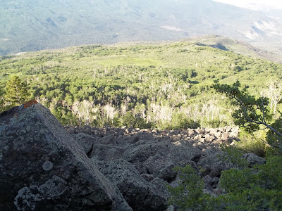
The Switchback trail is located on the south facing slope of the Grand Mesa above Coal Creek Basin. The upper end of the trail begins just off the Lands End Road and descends about 1000 feet to the Coal Creek trail. The mostly long sweeping switchbacks through the fields of basalt boulders make easy work of the otherwise steep slope of the rim of the Grand Mesa.
The trailhead for the Switchback trail is not very well marked. There is a small pullout just before a cattle guard that is about 3 miles east of the Lands End Observatory. The sign that marks the beginning of the trail is over by the edge of the mountain. There isn't an obvious trail between the parking area and the trail marker but once you get to the sign the trail is very obvious for the rest of the way.
You would think that any trail that takes you over the cliffs of the Grand Mesa would be a real challenge but this trail is truly a real delight to hike.
The upper portion of the trail is populated with a few spruce trees.
The spruce trees soon give way to a thick forest of aspens.
In spots there are clear views of the Kannah Creek drainage to the south and the Whitewater Basin to the west.
The Switchback trail ends after a little less than 1 mile when it meets up with the Coal Creek trail. The Coal Creek trail traverses around the Grand Mesa below the cliffs from the Wild Rose Picnic Area, just off of the Lands End Road, to Carson Lake on the Grand Mesa at the head of the Kannah Creek Basin. If you go left on the Coal Creek trail for a short distance you could continue downhill on the Coal Creek Basin trail all the way to the City Intake trailhead. To avoid having to hike back to the top you could make use of a shuttle ride.
The climb back up to the trailhead is only moderately difficult. That is especially true compared to other trails in the area such as Mt. Garfield.
I met a couple of squirrels along the trail that raised quite the alarm at my passing. I thought that perhaps they had a nest of babies that they were concerned about.
If you make this hike in the late summer you should be able to snack on some chokecherries and raspberries or perhaps pick a few blueberries on your trip up the Lands End Road.
You will undoubtedly notice the towering white rock plumes in the Whitewater Basin as you are hiking. A Ute legend identifies these as 'dropping and bones of animals consumed by giant eagles ..., who had their nests on top of the cliffs.' (Museum of Western Colorado) The Museum currently has a very nice display that speaks of the ancient Ute and Aztec history of the area that is very interesting.
I am still trying to learn whether this Switchback trail is the same trail that was originally built by John Otto, the famous trail builder known mostly for his work with the Colorado National Monument. He had envisioned a series of trails that would connect the Colorado National Monument with the Grand Mesa. He developed the Sunbeam trail that ran from across the Little Book Cliffs to Palisade. There it connected up to the Butterfly trail that ran across the top of the palisades and the boulder fields of basalt below the rim of the Grand Mesa. The trail eventually ascended a switchback trail to the top of the mesa. I have a picture of John Otto's original trail but I can't tell for certain if it is one and the same as the present day trail.
There is a lot of history along these old trails that makes them even more enjoyable to experience. If you would like to see some of it for yourself then all you have to do is 'Take a hike'.


