


Round Trip Distance: 6.6 miles
Difficulty: Moderate
Elevation: 4389 - 4762 feet
Cellphone: 0 bars
Time: 8 hrs.
Trailhead: Westwater Road
Fee: none
Attractions: lots of petroglyphs
The lower section of South Mill Creek, in Moab, Utah, that stretches through the canyon between the Steelbender trail and the very popular North Mill Creek trail is lined with numerous panels of petroglyphs that appear to have been created over a long period of time by multiple different groups of people. Many of the images follow several different Fremont styles while others appear to be much older archaic. Hiking along South Mill Creek in this area is mostly easy and very pleasant.

The trailhead on the Steelbender end of this section of South Mill Creek is near the top of the hill, on the right side of the road, after passing the Moab Golf Course on Westwater Drive. To get there drive south out of Moab on US-191 and turn left at the light onto the Spanish Valley Road. Continue driving straight for just under 1.9 miles, passing the Moab Golf Course Rock Art Site at 1.56 miles. From the parking area hike uphill along the pavement to the beginning of the Steel Bender trail and follow that over the crest of the hill and down into the South Mill Creek drainage. This part of the Steelbender trail is suitable for most vehicles but it is all on private property and there are no legal places to park other than where we have mentioned. At the bottom of the hill go to your left and hike along the right-of-way that skirts the nice looking pasture. The trail crosses South Mill Creek on a cement slab where the water is usually just over shoe deep if you happen to get off of the stepping stones.

After crossing the creek the trail turns left and passes through a fence. A few yards after that there is a hitching post where a side trail leads over to an expansive archway on the cliff where there are several panels of petroglyphs. The main panel has a large house of more recent construction added as graffiti to the original prehistoric images.

There are several good panels beneath the next archway to the right that might go unnoticed. The images here are much more interesting than the main archway panel. Notice the 2 larger figures that resemble the Classic Vernal Style like found at the more famous McConkie Ranch near Vernal, Utah. Notice that the smaller figure on the right is dangling a token of those suspected headhunters in the same manner as at McConkie Ranch.

The next waypoint that we marked is near the 1.2 mile point from the parking area. It is just off the side of the trail beneath a small overhang. Here you will find one boulder with some petroglyphs and another with 2 grinding grooves or metates. Near the 1.7 mile point there are several caves that both have a few petroglyphs near their entrances and on several small boulders.

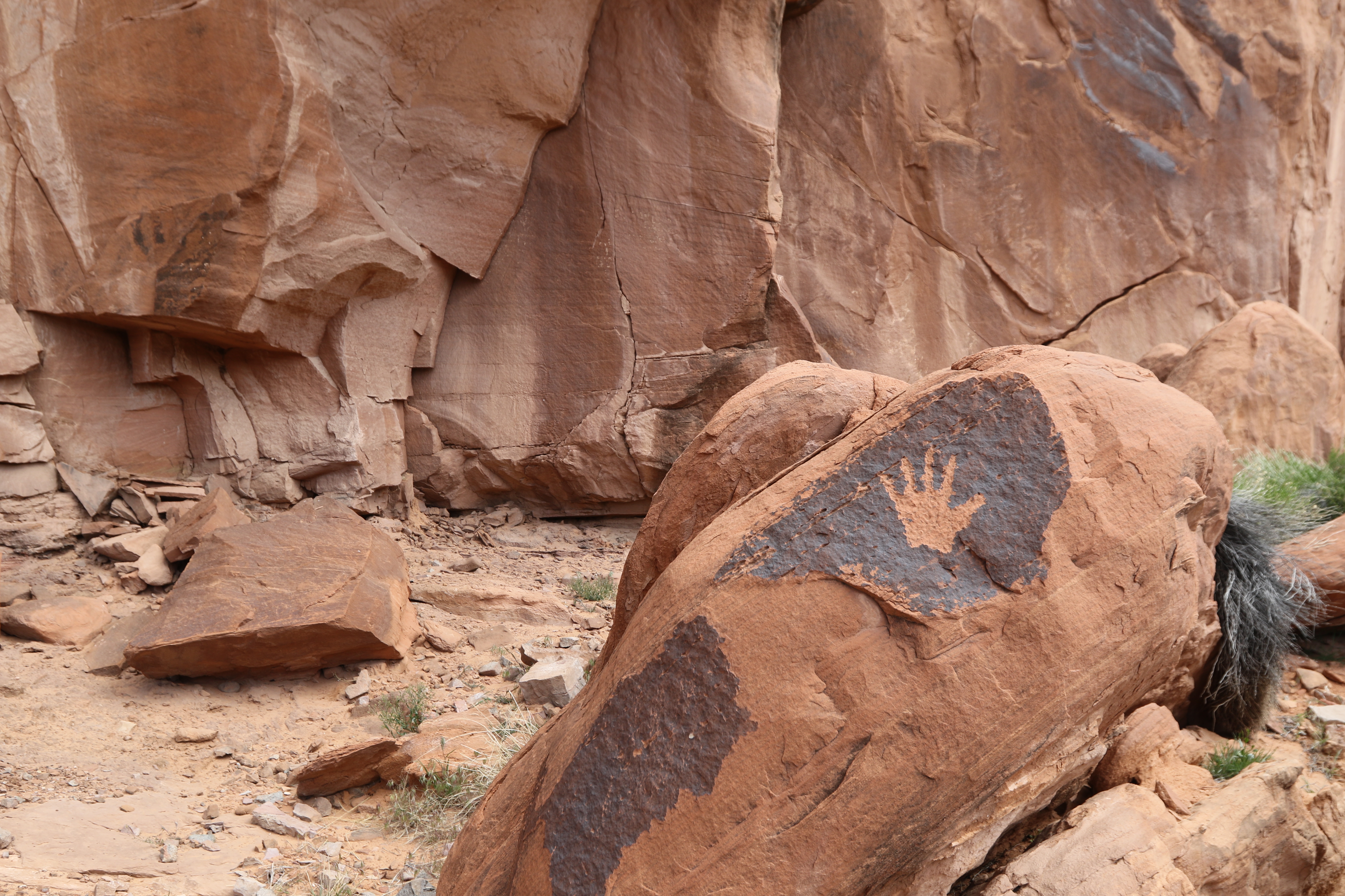
As you continue down the canyon there will be numerous more small panels on the nearby cliffs that are worth searching out. Some are quite unique compared to the others with styles of images made over a long period of time by many different groups of people.

This is part of an interesting panel that is easy to spot within 10 or 15 feet of the trail. Note the snake above the bearpaw with horns and a dragon like head. Zoom in on the head and you can see eyes and a forked tongue that looks like fire emitting from its mouth.

Another interesting panel has what might be owls and maybe a couple of faces with beards and necklaces.

We labeled this the Big Elk Panel because other hikers would ask us if we saw the one with the big elk. The entire panel spans 50 feet or so of the cliff. It's not too hard to get up onto the place where the one's that made the images had stood but from there you're too close to take photos.

About 50 feet or so to the left of the Big Elk Panel are 2 more panels that are partially covered up by a tree. The images right behind the tree are a little harder to make out but it is a rather densely populated panel that seems to portray an elaborate story.

As you continue down the canyon the trail drops down next to South Mill Creek as it progresses along it's east bank. Here there are numerous panels of petroglyphs, of which this one is an example, that come up one right after another.

This is the one panel that we noticed that is on the west side of the creek at the point of a cliff and about 20 feet above the trail on that side. The rake looking symbol at the top probably represents rain. Notice how most all of the anthropomorphic and animal images are connected by lines. There are shaman, people and maybe various gods that are all connected under the sky in some sort of religious theme perhaps.

The figure at the top of this panel might be the 'Four Armed Man' that we had heard mentioned elsewhere. There is also a panel nearby with what look like 'Sheep Men' that we had heard of also.

Bear paws are extremely common along South Mill Creek. Whether they have any relation to the 'Bear Clan' or 'Bear Dance' is something that we don't know.

Eventually the east side of the creek runs up against the cliffs. On this trip, rather than cross the creek and continue exploring, we chose to turn around and head back. We didn't have any former intelligence of anymore petroglyphs beyond this point but since we didn't continue we can't say for sure. We did find a few small panels on a higher bench that we marked on the map for which we also provided GPS coordinates.

 The more than 10 mile long stretch of South Mill Creek is a truly rare place in what is now Eastern Utah. There is the perennial stream with abundant fresh water for drinking and agriculture. We saw a few turkeys and deer tracks in the upper drainage and during the summer months there are the La Sal Mountains with all that they have to offer. There are no dryfalls that block travel, at least in the lower 8 miles of the canyon. All the panels with hunting type images might reflect the abundance of game but those Classic Vernal Style images seem to say that it wasn't always a peaceful place to live. If you would like to see it for yourself then all you have to do is 'Take a hike'.

