


Round Trip Distance: 0.2 miles
Difficulty: Easy
Elevation: 6453 - 6480 feet
Cellphone: 0 bars
Time: 20 mins.
Trailhead: Ruin Park Road MM 2.9
Fee: none
Attractions: Ancestral puebloan ruin
The Castle Ruins are located in the Ruin Park area of Beef Basin just south of the Needles District of Canyonlands National Park and 67 miles northwest of Monticello, Utah. Situated on the edge of a small hill the multi room pueblo style dwelling appears to have had one room, at least, that was 3 stories in height. Some people also refer to it as the Tower Ruin.

To get there travel north on Highway 191 from Monticello, Utah for 14.3 miles and turn west at the signs for Newspaper Rock and Canyonlands National Park. If coming from the other direction the turnoff is about 40 miles south of Moab. Continue for another 20.2. miles and turn left onto CR 107, the Bridger Jack Mesa/Beef Basin Road. There is a restroom and staging area with lots of parking at the turnoff. Follow CR 107 for 25.4 miles and turn right onto CR 104/aka FR 093. The sign at the turn says 12 miles to Beef Basin. We measured 9.4 miles to the sign in this photo. We strongly recommend 4wd with extra gas and since the area is so remote maybe even a shovel. From here zero your odometer and turn right toward Ruin Park.

At the 2.9 mile point turn left onto a spur road. If you stopped at the Catchment Granaries and the 10 Room Ruins then your mileage is probably off so measure 1.3 miles once you return to the Ruin Park Road from those ruins. There is little risk in missing the Castle Ruins since they are visible from the road and this is the first left turn that comes up in this area.

Follow the spur road for a quarter mile to the trailhead.

From your vehicle it probably isn't more than a couple hundred feet up to the ruins.
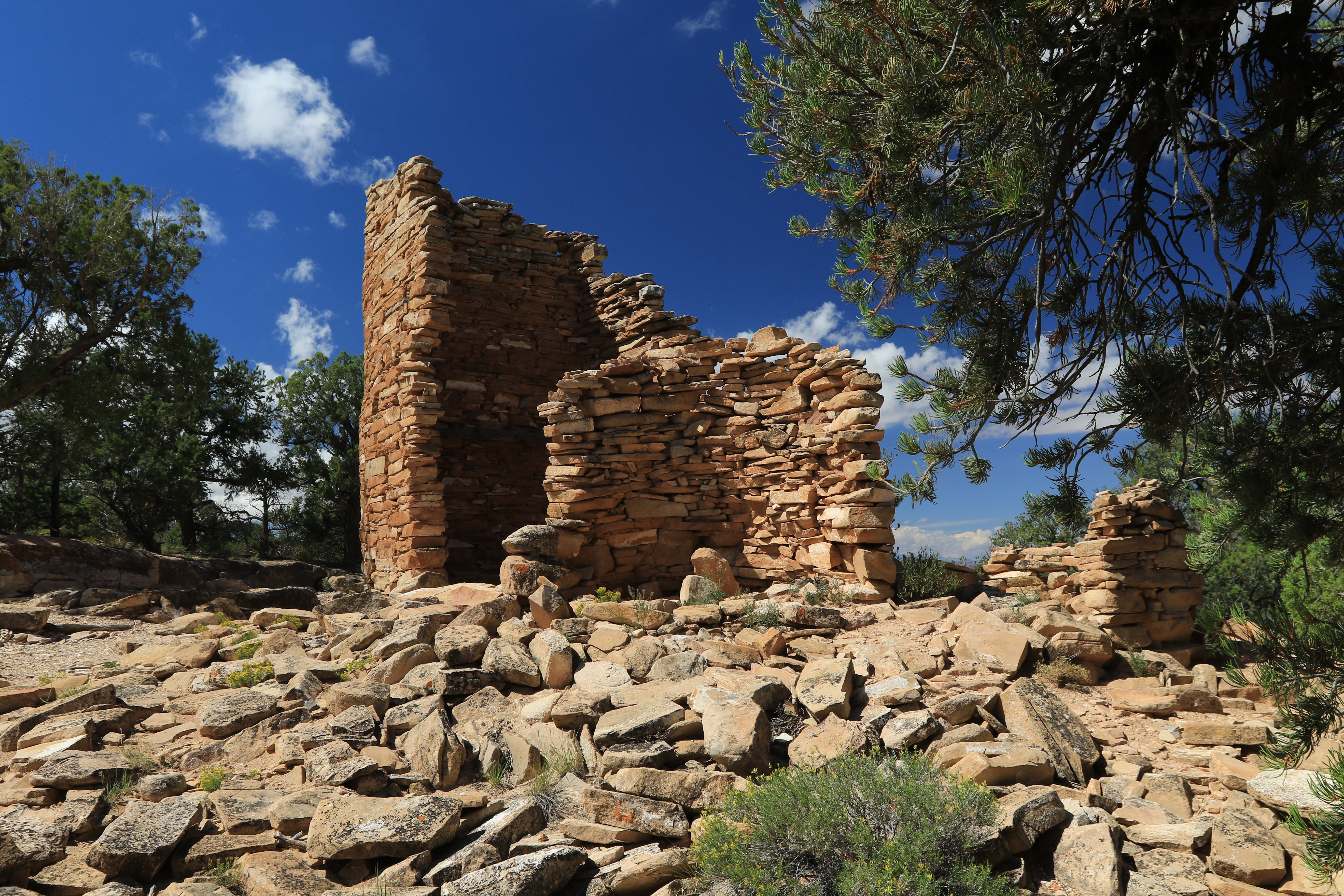
It looks like there was originally a tall square or rectangular room, a round room, and several outer rooms. An interesting investigation would be to calculate how much scattered building material is lying about and how much you could build with it. We're guessing that many of the stones that are scattered away from the main structures probably originally fell within and around the rooms and were later tossed there by pot hunters scavenging through the rubble.

It probably isn't wrong to think of these hilltop type ruins as the castles of the time. This one has a line of site view with the Farmhouse Ruins and several others. It's hard to say though which buildings existed or were inhabited at the same time.

There is one log still in place that was a support for one of the between floors. Clear away the rubble and anyone under 6 feet tall could probably have stood upright beneath it although it doesn't look like the second story floor extended all the way over to the right side of the room. There was a door here on the left judging from the section of evenly stacked stones that form an edge. The door didn't extend all the way to the ground.

We're guessing that this round room was probably used for storage. Our question is whether the round room was simply an aesthetic style of architecture or was there a functional purpose or maybe something traditional or spiritual.

We liked this view simply because it is reminiscent of the Square Tower Ruin in Hovenweep National Monument. We were also wondering about the hole near the top. Was it for ventilation or was it also a lookout hole?

