Round Trip Distance: 0.3 miles
Difficulty: Easy
Elevation: 3920 - 3966 feet
Cellphone: 3-5 bars
Time: 45 mins.
Trailhead: Grimes Point
Fee: none
Attractions: petroglyphs
The Grimes Point Archaeological Area is located near Fallen, Nevada. The area is managed by the BLM to protect the archaeological resources that include hundreds of ancient petroglyphs that are found on basalt boulders in the area, mostly along the Petroglyph trail, as well as a handful of previously inhabited caves are about one mile away in the Hidden Cave area.
To get to the Petroglyph trailhead head east out of Fallen for 10 miles and turn left at the sign for Grimes Point.
Stay to the left as the trail leaves the parking area at the fork where the Overlook trail branches off on the right.
Many of the petroglyphs date back to 7,000 years or more. When they were first created they were carved and pecked into the black layer of patina that covers the boulders. At that time the petroglyphs would have looked grayish white but over the thousands of years since then they now have their own coating of patina that is slowing building up and making the images almost as dark as the rest of the rocks.
The Petroglyph trail is interpretive in nature with plaques scattered around the loop that provide information about the petroglyphs and what is known about those that created them and why those people came to Grimes Point.
One of those interpretive signs explains the odd looking dimples on some of the boulders that were created by striking the surface of the boulder with a rock as part of the "Pit and Groove" style of rock art. These are some of the oldest petroglyphs at Grimes Point and probably date back 7,000 years or more.
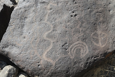
Presumably the petroglyphs on this boulder that consist of circular and wavy lines were created up to 3,000 years ago as part of a style that predates the style of petroglyphs with the straight lines by as much as 1,000 years.
Helicopters and military jets from the nearby Naval Air Station at Fallon provide background music while hiking around Grimes Point.
At the time many of the petroglyphs at Grimes Point were made the flat land in the basin would have been filled with water that was part of Lake Lahontan. Many of the petroglyphs are thought to have been made by shaman that would perform rituals while the hunters would conceal themselves behind the boulders waiting for game animals to come and drink at the edge of the lake.
On a bright sunny day such as this it is very easy to walk right by petroglyphs and not see them. Looking at this boulder from this angle there are a few images that are visible.
After moving off to one side there are even more images that can easily be seen. This is even with using a polarizing lens filter on the camera that blocks some of the reflected light.
It is interesting to try and imagine how all these lines and shapes may have been related to having a successful hunt. I suppose in a few thousand more years that a football play diagram will look just as baffling.
Petroglyphs don't get much more accessible than those at Grimes Point. It's fascinating to imagine people coming here to hunt on the edge of a lake that was still receding from the time of the end of the last ice age 12,000 years ago. Of course, the ice age had only been 4 or 5 thousand years before the time the earliest of the petroglyphs were made. Some of the petroglyphs can be hard to see if the light isn't just right but they are much easier to see than it is to take a good photo. If you would like to see it for yourself then all you have to do is 'Take a hike'.


