Round Trip Distance: 8 miles
Difficulty: Strenuous
Elevation: 8754 - 11,031 feet
Elevation gain: 2,761 feet
Cellphone: 0 bars
Time: 6 hrs.
Trailhead: Weehawken
Fee: none
Attractions: Forest hike, scenic peaks
The Weehawken trail is located in the Uncompahgre National Forest west of Ouray, Colorado. The trail begins off of the Camp Bird trail across from the Thistledown Campground where it climbs up the drainage of Weehawken Creek. The trail ends below the 11,000 foot elevation level in the brush along the creek. This post follows a primitive extension of the trail for about another half mile and turns around just above the 11,000 foot level. Hikers can enjoy dramatic views of Potosi Peak, Whitehouse Mountain and portions of Ridgeway and Teakettle Mountains while hiking into the basin and some good views of Hayden Mountain while hiking out.
To get to the trailhead drive south out of Ouray on the Million Dollar Highway and after the first switchback turn right onto the Camp Bird Road. Follow the Camp Bird Road for about 2.6 miles. The trailhead is on the right hand side of the road across from the Thistledown Campground where there is a restroom.
From the trailhead the route leads past a sign with distances for the various destinations. After that it comes to a registration box that we suggest that you be sure to sign. If Search and Rescue is called into the area it is helpful to them to know who is on the trail and where they were headed.
Looking at the map you can see there are a lot of switchbacks in the first mile of the trail. They make the initial climb much easier to handle.
The climb isn't all blood and guts though. Most of the switchbacks are the long sweeping kind that gradually take you higher and higher.
Near the 1.5 mile point the trail climbs above the 10,000 foot elevation mark and comes to an intersection where the Alpine Mine trail branches off on the right.
After passing the Alpine Mine trail the dramatic views begin as Potosi Peak comes into view.
The rate at which the trail climbs becomes a lot more moderate as it continues toward the basin. Several side creeks and streams cut across the trail with each of them presenting their own particular challenge. The first main creek, which in early September has slowed down to a trickle, comes up and the trail actually follows it upstream a short distance. Several cairns and a tree marker point out the route.
A couple of the other side washes have steep sections of scree that can make them somewhat precarious. It is the nature of much of the rock in the Ouray area to decompose into a gravelly scree that becomes the bane of some of the trails.
Somewhere around the 2.5 mile point a side trail branches off on the left that leads to the Weehawken Mine. We have never hiked it so we can't say anything about it. The trail continues past that junction and eventually reaches the talus slopes below Whitehouse Mountain where close attention to the cairns is required to stay on the easiest route through the rubble.
Here is a sample of some of the scenery that you will be enjoying at this point of the hike.
As the trail enters the trees again it comes to a fork where there is a large cairn. The left branch of the fork leads to a sign after a hundred feet or so that marks the end of the Weehawken trail. For this post we continued along the primitive extension for about a half mile after returning from the official end of the trail marker.
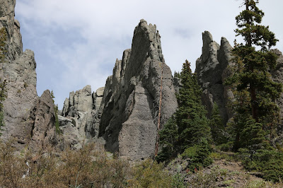
We turned around at a creek crossing where the trail conditions were quickly deteriorating. The close up views of the hoodoos that spire up along the base of the mountains slopes were well worth the extra hiking to see.
On the hike back we put the zoom lens on to take some closeup photos of the craggy peaks. Rotten rock like this probably isn't very appealing to mountain climbers.
Here is a photo of one of the pheasants that are quite common in the area.
And this is the massive Hayden Mountain that dominates the views to the south.
We only gave the Weehawken trail 3 out of 5 stars but that had more to do with the trail than anything else. The scenery and the ambience was all that you could hope for in a Ouray area trail. The trail could be greatly improved with a few steps imbedded into the scree in a few places. Also we weren't sure whether the extension past the trails official ending point was still under construction or whether that what we encountered was the final product. Other than that the views are 5 star all the way. If you would like to see it for yourself then all you have to do is 'Take a hike'.


