


Round Trip Distance: 5.1 miles
Difficulty: Strenuous
Elevation: 8,388 - 10,216 feet
Cellphone: 0-2 bars
Time: 3 hrs.
Trailhead: Battlement Reservoir
Fee: none
Attractions: Forest hike, deer, elk, bears
The Lava Creek trail is located near the towns of Parachute and Battlement Mesa, Colorado. The trail begins on private land before entering the White River National Forest where it climbs its way up the mountain to the Battement Reservoirs. The trail was reconstructed in recent years and has been kept in good condition ever since. With almost 2,000 feet of elevation gain along a very rocky path the trail gets only light use until hunting season each year.

There are several routes that will get you to the trailhead. The route that we have plotted here is pretty much the one the Forest Service suggests. Since getting to the trailhead can be a bit of a challenge we suggest that you print out the map and take it along. The Forest Service directions are as follows:
From Rifle, head west on I70 to Parachute (15 miles) and take exit 75. Turn left and follow County Road #301 across the Colorado River to Battlement Parkway and turn right. Follow the parkway to Stone Quarry Road (1.5 miles) and turn right to Battlement Cemetery (on left). Take a left after the cemetery on County Road #320. Continue east on #320 for about 5 miles to reach the trailhead.
County Road #320 is signed as Underwood Lane. After about 1 mile it crosses another road where it changes from pavement to gravel. Continue on the gravel road and at the 3 fork junction take the middle fork. At the next fork stay to the left. We have it all laid out in the slideshow at the end of this post.

The Lava Creek trailhead is on the right side of the parking area. Another option for getting to the reservoirs is to follow the old Battlement Road. This post follows the Lava Creek trail until it meets back up with the Battlement Road after about 2.5 miles where we turn around without actually going to any of the reservoirs. We plan on doing that when we post the Battlement Road hike.

The trail starts out as a pleasant stroll through the woods.

It crosses an oilfield access road several times as it progresses.

The trail crosses Lava Creek at least once. How much water you will have to deal with will vary according to the time of the year. The Lava Creek trail is on a north facing slope so you might want to hold off until after the middle of June before hiking it.

With a name like Lava Creek you can pretty much count on encountering lots of basalt boulders to hike over.
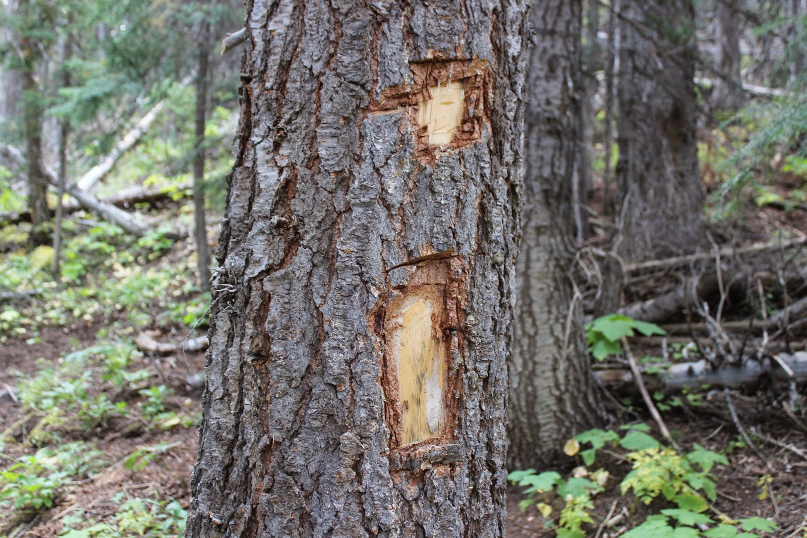
The trail is pretty easy to follow but as a reassurance you can keep an eye out for some 'tree scab' style trail markers that look like a square chipped in a tree over top of a rectangle. We noticed at least 3 or 4 of them as we hiked. This one looked pretty fresh but some of the others looked much older.

Once the trail gets above 10,000 feet it gets out of the basalt and levels off a little as it travels through several open parks.

The aspen trees give way to thick stands of spruce as the trail comes to an end at the Battlement Road. From this point the reservoirs are about another quarter mile to the right.

For most of the hike the trail is in the trees and distant views are limited. This picture was taken on the return trip looking north. From here you can see completely over the Book Cliffs, north of Parachute, and across the Piceance Basin area.

It has been over 40 years since the Battlement Creek fire burned through this area in 1976. The forest has grown back but remnants of the fire can still be seen. Three firefighters and a pilot lost their lives fighting the fire.

Usually I can take the latitude and longitude where I find cabins like this, convert them to township and range, and then look up the original land claim on the BLM's General Land Office Records website to come up with the name of the person that would have built the cabin. In this case I can't say for certain but it may have been filed on in 1894 by a Peter Churchfield.

