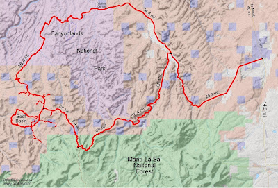
Beef Basin is a rather remote area in Utah that is just south of the Needles District of Canyonlands National Park and according to at least one map within the boundary of Bears Ears National Monument. The area is divided into 6 main sections; House Park, Middle Park, Ruin Park, Beef Basin Wash, Beef Basin and Ruin Canyon. Beef Basin's main attraction is its dense population of ruins that mainly include pueblo style structures, cliff dwellings and rock shelters.
At one time the Beef Basin area was better visited and its roads were in better condition. At present the roads in Ruin Park are still in pretty good shape and can be driven with 2wd vehicles although 4wd is highly recommended for accessing the area. Currently the north side of the Beef Basin Loop is so washed out that it is barely passable in places with 4wd. Beef Basin Wash and Ruin Canyon are both overgrown with brush and require 4wd. Expect to get the sides of your vehicle scratched up quite a bit in both canyons. Michael Kelsey's book 'Hiking, Biking and Exploring Canyonlands National Park and Vicinity' includes a crude map and driving tour of Beef Basin. Where it seemed reasonable we tried to align our names with those in his book.
This group of 26 posts will cover over 40 ruins that we have identified in the Beef Basin area. Some of the sites are mentioned in Kelsey's book while others we discovered either while exploring or using Google Maps satellite view to spot obvious structures.
The shortest route into the area is via the Elephant Hill extreme 4wd road that begins in the Needles District. Since that is the least favorable option due to its difficulty most visitors access the area via San Juan County Roads 107 (aka the Bridger Jack Mesa Road) and 104 (aka the Beef Basin Road). A third option is to drive around the south side of the Abajo Mountain and arrive via Forest Road 88. While you can enter 'Beef Basin' into Google Maps for turn by turn directions it will try to route you up the North Cottonwood Creek Road which is not a drivable route. If you ignore its constant prompts to get you to turn on that road until you pass Wilson Ranch the rest of the instructions will work out well.
We highly recommend bringing a shovel to fill in any ruts or use to dig yourself out as well as extra gas. There are numerous primitive campsites throughout all of the parks and canyons. Be sure to never camp in or around any of the ruins. It took us 3 full days to find and explore most of the ruins on this map but at least 2 more days would have been better.
Currently the only place to get a cellphone signal is right before dropping into House Park.


