


Round Trip Distance: 8 miles
Difficulty: Strenuous
Elevation: 10,819 - 12,438 feet
Cellphone: 0 bars
Time: 5 hrs.
Trailhead: North Fork Creek
Fee: none
Attractions: alpine lake
The North Fork Creek trail #1483 is located in the Mount Massive Wilderness Area of the San Isabel National Forest between Aspen and Leadville, Colorado. Traveling up the North Fork drainage the trail provides multiple hiking options. The most popular route leads up to the small but scenic North Fork Creek Lake. From there another trail crosses the Continental Divide into White River National Forest and descending to join the Fryingpan Lakes trail. There is also a route that climbs the west drainage and crosses the divide into the Marten Creek drainage, as well as routes to Deer Mountain Lake and Blue Lake.

The trailhead is near the last hairpin corner at the base of the eastside of Independence Pass about 24 miles east of Aspen and 34 miles west of Leadville. For turn-by-turn directions enter 'North Fork Lake Creek Trailhead' into your driving app.

The trail starts out following a double track that once led to a mine at the mouth of Lackawanna Gulch.

Around the 3/4 mile point the trail enters the Mount Massive Wilderness Area. A few yards further and it crosses the creek that drains Blue Lake. A very primitive and steep trail that branches off on the left at this point climbs up to Blue Lake. There will probably be a few sticks across the start of that trail that are meant to steer hikers to North Fork Lake from turning there.

A little ways into the Mount Massive Wilderness the trail continues up the valley away from the sheltering trees of the forest. For reference, as the trail approaches the mountain up ahead it will head up the drainage on the right.

Near the 2.2 mile point from the trailhead the trail brushes up against the creek and becomes very narrow. To stay on the main route you will want to cross the creek at this point to reach North Fork Lake. There seems to be an aversion to trail markers and signs so just remember that when the trail gets so narrow that you are about to fall into the creek that you should actually cross it anyway. Of course, you can go just a little further and cross where the creek is narrower and then get back onto the main route.

After crossing the creek and getting up the opposite bank the well established trail is once more apparent.

In the side drainage all trees are left behind. There is another small creek crossing where the tundra is very soft and spongy. It is at this point that you might notice a very faint trail that angles up the slope on the right that leads up to Deer Mountain Lake.

Like most alpine lakes there is a steep climb to get up to the basin that holds the lake. This particular climb gains more than 400 feet of elevation which takes it above the 12,000 feet mark. The lake itself is around 12,372 feet above sea level.

The view of the lake as you approach it isn't all that scenic from that direction.
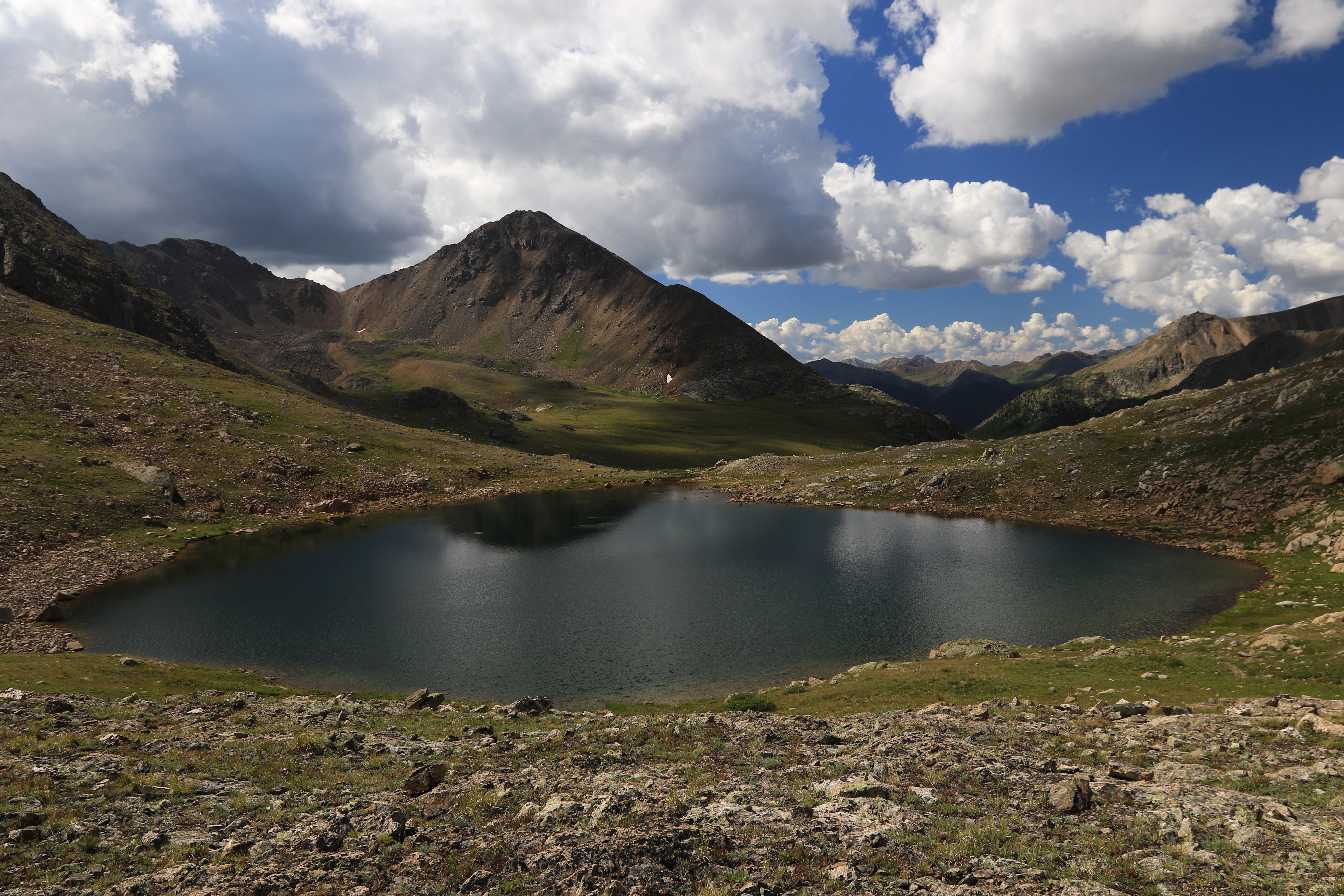
All that is needed is to hike on around the west side of the lake and get up on the little ridge for the view to become spectacular.

As an added bonus there is a nice view on the north side of the ridge of the Fryingpan Lakes. The ridge itself is the Continental Divide and forms the boundary between the San Isabel and White River National Forests. The trail over the ridge is known as Fryingpan Pass and will take you up to 12,438 feet. Crossing the ridge also takes you from the Mount Massive to the Hunter Fryingpan Wilderness Area. The trail, which is faint at this point, does descend and join the Fryingpan Lakes trail.


By the time we got back to the trailhead there were a couple dozen vehicles parked all the way out to the highway. Even though the skies were clear when we set out it had begun to rain at this point, even becoming intense at times as we left. Most of the North Fork Creek trail travels out in the open with no shelter from the elements. In the past this trail only saw a handful of hikers all summer long but as you can see it is now very popular. If you would like to see it for yourself then all you have to do is 'Take a hike'.