


Round Trip Distance: 18.8 miles
Difficulty: Easy
Elevation: 4206 - 5978 feet
Cellphone: 0 bars
Time: 7 hrs.
Trailhead: Highway 95 MM 11
Fee: none
Attractions: Scenic canyon, rock art
The Poison Springs Canyon Road is located 11 miles south of Hanksville, Utah off of Highway 95. The road travels through the scenic canyon for 16 miles before reaching the Dirty Devil River. On the east side of the river the road continues and eventually connects with several other routes including one that leads back to Highway 95 near Hite. For this post we follow the road for the first 9.4 miles before turning around. Enroute we stop at 3 different rock art sites plus a short trip up a side canyon to a cave that has several Barrier Canyon Style pictographs.

The turnoff is on the east side of Highway 95 just past mile marker 11. (Mile marker zero is at Hanksville.)

As you follow the road bear right just past the quarter mile point. Just past the half mile point there is a staging area on the right for those that are pulling trailers to offload their livestock or OHV's. At the 2 mile point there is a kiosk for Poison Springs Canyon. At the 2.4 mile point there is a primitive campsite on the right before the road drops down into the wash. Highway vehicles can probably manage the road up to this spot and park here. At the 3.3 mile point the road crosses a cattleguard and at 3.4 miles it is rejoined by the route that split off near the quarter mile point which we understand is an abandoned route. There are a few short rocky stretches and several moderately deep sandy places but other than that the road isn't too bad.

At the 5.8 mile point from Highway 95 there is a route that branches off toward the cliffs where Site I is located. If you happen to be driving in the main wash going through here you will miss the turn although most vehicles appear to leave the wash and follow this route. The petroglyphs are visible from the road if you are looking for them. This is also the first part of the canyon where water is common throughout the year and also the first place where there are cottonwood trees.

There are more petroglyphs here than we could possibly show so we picked only two. We particularly liked the image of the hunter and buffalo in this photo.

This large figure, with what looks like a snake for an arm, is next to an equally large bighorn sheep. Many more images from the site can be seen in the YouTube slideshow at the end of this post but even from that we had to cull around 400 photos to cut it down from its original 12 minutes runtime.

Less than a quarter mile past Site I there is a side canyon on the left hand side of the wash. Several hundred yards up the side canyon is what many refer to as Poison Springs Cave. On the back wall of the deep cave are several pictographs. To take better photos than what we produced consider bringing an artificial light source and perhaps a tripod. We took several photos without a flash that would have come out fine with a tripod. There is a subterranean room within the cave that is also interesting. Several scrambling routes can be found leading up to the cave but there is also an easier walk up route about a hundred feet or more before both of those.

Site II is right around the 7.2 mile point. Since pulling off the road can throw your mileage off a little it might be better to go by the GPS waypoints to find each site. These panels are also visible from the road if you are looking for them.

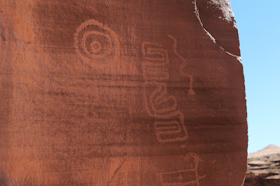
There are even more images here than at Site I. This image might be called The Talking Head. It has 2 large eyes and a harder to see nose. For a mouth it has 2 circles connected with a line that sometimes represents 2 men talking. Of course, it could represent a kachina. The 4 circles could represent the 4 directions. The diamond chain extending up at an angle on the right could also represent snakes once again.

Snakes are a common theme at all the sites and might even be clan related.
This panel with its geometric meanders is on a side abutment and is easy to miss.

Amongst the other numerous panels is this hunting panel that is apparently Ute in origin as noted by the riders on horseback.

A little before the 9.4 mile point there is a very wet stretch of road with lots of trees and brush. Tucked away next to the cliff is a spring that has been dammed off with a wall of rock that has an iron door for a flood gate. Standing next to the structure you can hear the water gurgling up within.


A little before the 9.4 mile point there is a very wet stretch of road with lots of trees and brush. Tucked away next to the cliff is a spring that has been dammed off with a wall of rock that has an iron door for a flood gate. Standing next to the structure you can hear the water gurgling up within.
At the 9.4 mile point there is a nice primitive campsite on the right that sits a little above the bottom of the wash. Site III can be seen directly across the road from the campsite. Most of the images are along a shelf about midway up the cliff but there are a couple of fighting warriors with knives and shields lower down that are worth searching out.
It is probably easier to take photos from down below using a zoom lens than from up on the ledge but we did both. This large bighorn with a snake that runs the length of its body further perpetuates the snake theme of the canyon. Below and in front are several more bighorn that are being followed by a snake with a larger snake above that and a couple more less obvious snakes. We take these snakes to represent hunters possessed by the mystic symbolic power of the clan.
To the right of a large inscription that is dated to 1958 is a long line of diminishing sheep. It is the inscription itself that tends to draw ones attention to the rock art.

 We read from one source that named this last spot the Butch Cassidy Camp and claimed his inscription to be found behind a large boulder at the edge of the camp. While we don't doubt Butch Cassidy frequenting the canyon the inscription appears to read 'CASEY'. Other sources that we read labeled the road as extreme 4WD and one even claimed that it might be too narrow for a full sized vehicle. We tried to include enough photos in the slideshow to give an idea of how we found the road. We can vouch that we had no trouble at all driving the first 10 miles in our Tundra so the extreme conditions must be further on. There were a few spots that were a little rocky but they were short in span as were several places where the sand was a little deeper. The only other vehicles that we encountered were a side-by-side and a bult for highways SUV. We also met 2 backpacking vloggers (video loggers) that were hiking the 812 mile Hayduke trail who interestingly enough missed seeing any of the rock art. It seems a shame to hike so far and miss so much. With the right amount of advanced preparation Poison Springs Canyon can make for a fun day. If you would like to see it for yourself then all you have to do is 'Take a hike'.