


Round Trip Distance: 4 miles
Difficulty: Moderate
Elevation: 4948 - 5387 feet
Cellphone: 0 bars
Time: 2 hrs. 45 mins.
Trailhead: Old Woman Wash
Fee: none
Attractions: Rock art, scenic geology
Old Woman Wash is located in the San Rafael Swell near Hanksville, Utah. This post follows a trail through the scenic wash and into the reef where it makes a loop that takes it past several interesting rock art panels, one of which consists of both pictographs and petroglyphs. The backside of the loop doesn't have any obvious trail to follow which makes route finding purely subjective. The following description, slide show and map should be enough of a guide for an experienced hiker.

Getting to the trail requires a moderate to high clearance vehicle or other suitable conveyance to cover the 2.3 mile distance from the highway to the trailhead. Begin by measuring 21 miles from Interstate 70 Exit 149 west of Green River, Utah or 22 miles north of Hanksville to mile marker 138.9 on Highway 24. A brown carsonite marker labeled with Trail #922 designates what we are calling the Old Woman Wash Road.

Reset your odometer after turning off of the highway. At the 0.4 mile point and the 1.5 mile point stay left. Go right at the 1.8 mile point and right again a very short distance past that. At the 2.2 mile point go to the left where the road loops around the remains of an old fireplace at the trailhead.

From the parking area the trail passes through a corral pole fence and enters a Wilderness Study Area. The well worn trail continues until it finds its way into Old Woman Wash.

For the most part the wash is wide with a mix of loose sand and slickrock for a base.

At the 1 mile point from the trailhead the wash splits with the main channel going to the right. This is where we begin a loop that travels around the massive bulk of sandstone in this photo. The direction of travel is purely arbitrary and probably doesn't matter difficulty wise.

Off to the right at the point where the canyon splits there is a very faded panel of rock art. We did a rough outline of a few of the images using red for the pictographs and white for some petroglyphs. The image on the far right resembles a rainbow with falling rain. There is also a sheepherder inscription and a few more pictographs that look like a man, woman and 2 children.

For this post we continued up the right branch of the canyon after checking out the rock art. On topo maps the right branch is the main branch of the canyon. As the wash begins transitioning from sand and rocks to slickrock there is a very faint trail that leaves the wash on the left. If you stay in the wash it quickly reaches some spillovers and becomes unhikeable. At that point it is much more difficult to get up to the trail.

There is at least one more panel of very faint pictographs on the cliffs to the left of the trail. We may have passed by a better panel that we thought we could see at one point but didn't notice again as we continued.

In a few spots the trail looks like an old jeep road. It follows a route that stays well above the wash that takes it around the point of the cliffs off in the distance.
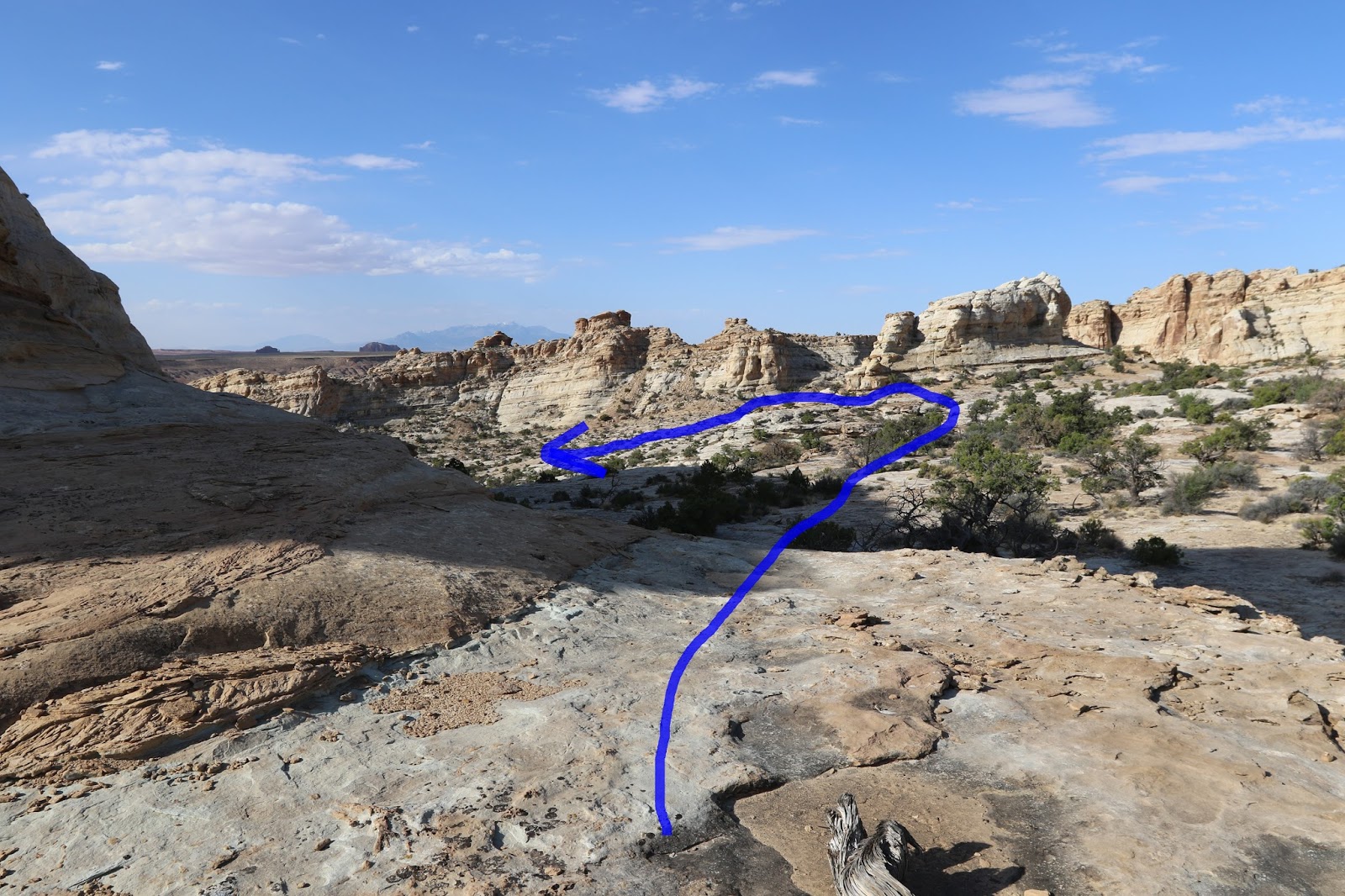
After rounding the point of the cliff the idea is to begin circling around toward the other branch of the canyon from the low ridgeline that separates the two branches. Route finding becomes more of a personal matter at this point. For those that don't mind scrambling over the short ledges to get off of the ridge all they have to do is find a spot that they feel comfortable with. We ended up working our way over to a knob near the middle of the canyon before scrambling down.

The spot that you will want to head toward with the main rock art panels is near the south end of the cliffs on the left. Once you get close the site is easy to spot.

Close examination reveals some faint petroglyphs mixed in with some of the pictographs. The petroglyphs appear to be much older but that might not be the case at all. The main figure on the upper left might be wearing a necklace with a medallion hanging from it.

Unfortunately much of the detail of the panels has faded away. The snakes that we outlined in red that are between the tall ghostly figures actually look more brownish in color.

Overall it is still a pretty cool site to visit. There are more faint pictographs along the cliff to the right as well as some other petroglyphs that are somewhat unique.

From the rock art the route continues by dropping down into the wash and following it through a narrow gap and back to where the loop began. There is some minor scrambling along the way but nothing difficult to deal with. We thought that this part of the loop was some of the funnest to hike.

