


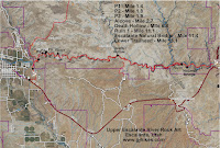
One-way Distance: 13.1 miles
Difficulty: Moderate
Elevation: 5205 - 5834 feet
Cellphone: 0-3 bars
Time: 3 hrs. 45 mins.
Trailhead: Upper Escalante River
Fee: none
Attractions: rock art, ruins, natural bridge
The canyon of the Escalante River, from the town of Escalante, Utah, downstream for 13 miles to where it is crossed by Utah Highway 12, has a half dozen interesting rock art sites, several ruins, a few natural arches, and the Escalante Natural Bridge. This post covers the upper 3 miles of the canyon where most of the rock art sites that we know about are concentrated.

To get there, turn at the sign for the Escalante Trailhead Jct. on the east end of Escalante. When you reach the cemetery turn right and cross the cattle guard. Before reaching a water tank that you will see up ahead turn left at another sign for the trailhead and continue to the primitive parking area. For turn-by-turn directions enter Escalante River Trailhead into your driving app and choose the one at 190 N.

Backpackers can fill out the required free Overnight Use permit at the trailhead and hikers can sign the register before setting out. These actions make it easier for Search and Rescue crews if they are ever called to the area.

From the parking area the trail follows the road as it continues down the ridge to a turn around where the trail cuts across some private property. From there the trail crosses a dry wash where it tunnels nicely through a forest of tamarisk before coming to another fence at the mouth of the canyon.

With a lot to see through its course the scenic canyon of the Escalante can be very pleasant to hike. Be aware that the trail crosses the very shallow creek multiple times.

The first petroglyph site, which consists of several panels, comes up on the left side of the canyon at the 1.4 mile point from the trailhead.

The second panel at the first site has a couple of very faded Fremont style anthropomorphic images and a number of circles. The type of fading that you see in the middle of the panel is that which comes from the rock being touched by people. You can see how it eats away not only the patina on the rocks surface but even dissolves the rock itself.

Continuing on down the canyon for another 4 tenths of a mile to mile 1.8 there is a small panel of etchings higher up behind a sand hill on the left side of the wash that we labeled as UE P2.

The third panel of petroglyphs at mile 1.9 is also on the left side of the wash. Here there are several more anthropomorphic images and a bighorn sheep that is standing on some concentric circles.

On the left hand side of the canyon at the 2.7 mile point there is a huge alcove with multiple panels of pictographs.

The brochure in the tin box at the site shows that these images were originally brown and white. Some of the brown is still visible under close examination.

Here are some painted concentric circles that were placed beneath a small ledge in the back of the alcove. Taking the trouble to place the image in this exact spot might indicate that is was part of a solstice calendar.

These images display the same colors that we have seen in some Paiute pictographs in other areas like Snake Gulch.

 We did the hike for this post in the middle of July, as an out-and back to the alcove, when the temperature was in the 90's. There was a gentle summer breeze drifting through the canyon for the entire hike. The stream bed was dry enough that for all the times that the trail crosses it the water was either no more than ankle deep or completely dry. It really seemed like an ideal time for making the hike. There was another group on this same day that had left a vehicle at each trailhead and hiked the 13 miles one-way. However you go about it you will hopefully find it as enjoyable as we did. If you would like to see it for yourself then all you have to do is 'Take a hike'.

