Round Trip Distance: 1.4 miles
Difficulty: Easy
Elevation: 6114 - 6253 feet
Cellphone: 0-3 bars
Time: 1 hr.
Trailhead: Alkali Ridge NHL Marker
Fee: none
Attractions: cliff dwelling, rock art
Chokecherry Spring is the name that we have given to a site in Alkali Canyon, east of Blanding, Utah, that is within the boundaries of the Alkali Ridge National Historic Landmark area. The site includes some remnant walls of a cliff dwelling, some very interesting rock art, and a few grinding slicks.
Measuring from the turnoff from US-191 onto the Alkali Ridge Road, CR 204, drive for about 7.4 miles and turn right onto a faint 4WD road.
Within an hundred yards or so the road comes to a junction where the Alkali Ridge National Historic Landmark monument is on the right. Those that are in 2WD highway vehicles can find a place to park in this area and hike the remaining half mile or so to the site.
After passing the marker the road passes through an area where there are quite a few pithouses and them makes a beeline in the direction of the branch of Alkali Canyon where the spring is found.
A little before reaching the canyon the route jogs to the right and finds its way to a dugway that ranchers made for their cattle to be able to get down to the spring. If you have any trouble finding the jog in the route before reaching the rim of the canyon all you have to do is follow the rim to the right until you find the dugway. There is a fence on the east side of the dugway that can also be used for a guide to where the route drops down into the canyon. As can be seen from the photo the dugway starts out pretty rocky.
At the bottom of the dugway there is a plush area where water from the spring is captured in a water tank. The ruins are within an alcove right behind this. You can't miss it. There is a light chain across the opening to keep cattle out of the alcove.
The most noticeable part of the ruins sits up on a high shelf. It's easy enough to scramble up to the shelf but there is really no reason to get any closer than to take a photo.
At one time there were also rooms in the open area down lower where remnant walls still remain.
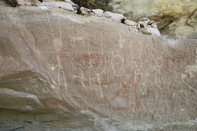
The highlight of the site is the rock art which includes both petroglyphs and pictographs.
The images with the long antennae look to be of the same style as those at the Gypsum Valley site along the Dolores River which is over 40 miles away as the crow flies.
Other images include some sheep and a couple of bears.
Right below the main panel of images are some grinding slicks and petroglyphs.
There are also some grinding slicks with petroglyphs inlaid.
Good patches of chokecherries can be found throughout this branch of Alkali Canyon including these that are right within the alcove with the ruins. There is also a little bit of poison ivy that you will want to avoid.
If anyone knows of a more common name for the site we would be glad to change our title to reduce any confusion. While the spring at the site has been developed we have yet to see a map that gives it a name. When we made our trip to the Chokecherry Spring Ruins we actually started at the head of this branch of the canyon near the pipeline road thinking that we might be able to find a place to drop into the head of the canyon and explore it downstream. This dugway ended up being the first good place to get into the canyon. For others that just want to visit this site the easiest approach is what we described above. If you would like to see the Chokecherry Spring Ruins for yourself all you have to do is 'Take a hike'.


