One-way Distance: 2.2 miles
Difficulty: Moderate
MTB Skill level:
Elevation: 7117 - 7535 feet
Cellphone: 1-4 bars
Time: 45 mins.
Trailhead: County Road 10
Fee: none
Attractions: Fun singletrack
Rattus Maximus is located in the RAT-Ridgway Area Trails System near Ridgway, Colorado. The lower end of the trail begins near County Road 10 where it travels up the west side of San Juan Ridge ending where The Big Cheese, Speedy Gonzales and Rat Trap trails all come together. Besides being a moderately easy route up the ridge Rattus Maximus provides access to many of the other trails in the area.
This post begins at the top of Rattus Maximus and follows the trail in the downhill direction.
As the trail starts out it drops off a little knob and lands on a double track. It only follows the road for a short distance before it branches off on the left.
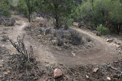
Nice wide switchbacks like this one are what makes Rattus Maximus one of the easier routes for going in the uphill direction.
As the trail continues it works its way through the widely spaced trees descending at a gradual pace.
At the 0.7 mile point the trail makes another encounter with the road and is crossed by the Rat Trap trail.
Rattus Maximus continues for a short distance where it passes the top of the Double Crosser trail.
From there the peaceful meander through the trees continues.
Another intersection comes up where Rattus Maximus and the Rat Trap share routes for a short distance.
The two trails travel together for maybe a hundred yards or so and then go their separate ways again. As Rattus Maximus continues it has several more encounters with the road.
As Rattus Maximus nears the 1.5 mile point The Maze trail begins on the left.
The trail continues gradually losing elevation as it works its way down the side of the mountain.
Around the 1.8 mile point Rattus Maximus meets up with The Maze once again. The two trails share routes as they travel along the edge of the gravel pit road. After a short distance Rattus Maximus crosses the road and continues downhill. On the east side of the road is also where the Gnawley Line trail, which heads uphill for a little over a quarter mile, begins.
Rattus Maximus comes to an end after a little more than 2.2 miles from the top. Across the road is the beginning of the lower end of The Maze trail. To get to the trailhead from this point it is 1 mile down the gravel road to County Road 10 where it is another quarter mile or so to the trailhead. The land on both sides of the gravel road from this point out to County Road 10 is private property. Rattus Maximus is the easiest route up on the west side of the mountain and a whole lot of fun going down. If you would like to see it for yourself then all you have to do is grab your bike or 'Take a hike'.
NOTE: All trails are closed between December 1 to April 30.


