


Round Trip Distance: 28 miles
Difficulty: Strenuous
MTB Skill level:
Elevation: 5066 - 7321 feet
Elevation gain: 4,963 feet
Cellphone: 0-5 bars
Time: 8 hrs.
Trailhead: North Fruita Desert
Fee: none
Attractions: Singletrack/Doubletrack mixer
The Edge Loop is a 28 mile long romp around the 18 Road trail system north of Fruita, Colorado. The loop is formed by combining the Prime Cut and Frontside trails with over 14 miles of roads and doubletrack that take the trail behind the Little Book Cliffs where it travels up Coal Gulch. From the top of the Book Cliffs the trail sets off on a downhill run of additional singletrack via Lipan Wash. After spilling out of the canyon the trail travels around the foothills to get back to the trailhead. The mountain biking skill level for the road and double track sections of the trail ranges from easy to moderate and the singletrack is a mix of moderate to difficult. Like the Sarlacc trail the Edge Loop is closed seasonally from December 1st to April 1st.

The trailhead is in the North Fruita Desert near the end of 18 Road. From the Circle Park in downtown Fruita follow E. Aspen Avenue east to Maple St. and turn left. Continue on 17 1/2 Road for almost 3 miles and turn right onto N 3/10 Road. Follow N 3/10 Road for a half mile and turn left onto 18 Road. Continue on 18 Road for another 7 miles to the trailhead. There are road signs at most of the turns that mark the way. The road turns to gravel after crossing the canal and parts of it can be washboardy at times. A lot of effort has been put into upgrading the road lately and it continues to improve.

The normal route begins by following the Prime Cut trail from the trailhead for 2.5 miles to the Frontside trail and following it for 3.6 miles to where it dumps out onto the Coal Gulch Road.

The road up Coal Gulch is graveled and as it starts out the elevation gain is real gradual for fast and easy riding. At the 8.1 mile point from the trailhead, or 2 miles from the end of the Frontside trail, the lower end of the Sarlacc trail begins on the right.

Follow the right fork in the road near the 12.6 mile point. From here on the trail begins climbing at a much steeper rate.

At the 12.9 mile point the Sarlacc trail reconnects to the road.

The climbing doesn't let up much except for a few short stretches.

Sometime over the last few years, since we were here last, trail markers have been added at the various intersections along the road. There are a few roads that branch off that aren't marked but most of those only lead a short distance to well sites.

At the 16.5 mile point the trail passes the Hunter Canyon Compressor Station whose units can be heard chugging away for quite some distance.

A 3-way intersection comes up at the 16.7 mile point. The Edge Loop follows the middle fork that continues climbing for another little bit as it heads off onto Ross Ridge.

Several more well site roads branch off on the right before the Edge Loop reaches the 17.5 mile point where the road turns into a more primitive doubletrack.

An overlook comes up near the 18.8 mile point. This is a good spot to rest up and take in the views of the valley before starting the downhill stretch.

From the overlook the doubletrack drops down a few very rocky and steep sections that most riders are going to want to get off and walk. The trail levels off after giving up quite a bit of elevation and continues along a lower rim of the cliffs. At the 20.3 mile point a trail squeeze on the right side of the road marks the beginning of the singletrack.

The singletrack starts out descending the backside of the mountain and after about a mile of winding its way through the pinyon and juniper forest it drops into Lipan Wash. This is at about the 21.4 mile point of the trail. The upper part of the wash is rated difficult at best in a few places where it is hard to maneuver around the rocks.
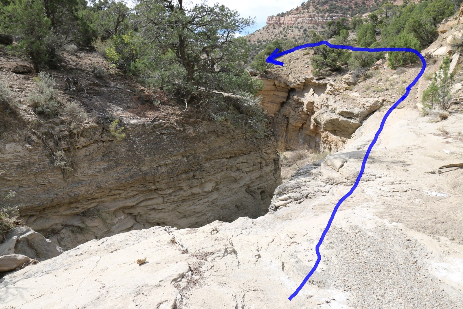
The trail comes to a big spillover that it bypasses on the right. Someone has left a permanent anchor with a knotted rope at the top of the spillover if you feel like going over the edge instead of going around. We contemplated lowering our bikes with the rope before climbing down ourselves but decided we had way too much money tied up in them to mess with that.

The wash gets pretty sweet after the spillover where it is smooth sailing for some pretty long stretches between rock jams and such. The further you go the more it turns into a raceway.

At the 23.8 mile point the canyon opens up and the Edge Loop Cutoff trail breaks off on the right. Some maps show the Edge Loop leaving the wash at this point but the trail markers have it continuing down the wash.

The best part about continuing down the wash is that it is easy to ride and fun blasting around the bends. The bad part is that there isn't a marker where the trail leaves the wash. We had been here a few months prior and we blew right past it and had to backtrack. The turnoff is at the 24.4 mile point where a trail crosses the wash. The trail to the left goes on for a ways before coming to a dirt road that can be followed to the left for maybe a mile or taken to the right and eventually reaching 18 Road.

Most of this part of the Edge Loop is fast and easy to roll over but there are a couple of gulleys that might come as a surprise.

The trail crosses the Layton Wash Road and after a short distance makes a left turn around the corner of a corral where it is met by the lower end of the Chutes and Ladders trail. Some of the same maps that have the Edge Loop leaving the wash at the mouth of the canyon also have it coming down the Layton Wash Rode to this point before turning towards the trailhead. A trail marker at the intersection points to the singletrack as the correct route though. We have gone both ways so as usual it is whatever you feel like doing at the moment.

From its intersection with the Chutes and Ladders trail the Edge Loop is an easy to moderate ride all the way to the trailhead. At the top of one hill the Down Uppity trail branches off on the right. The Edge Loop then drops down into a valley where it combines with the Vegetarian trail for the final stretch.

