Round Trip Distance: 6-8.5 miles
Difficulty: Moderate
MTB Skill level:
Elevation: 9259 - 9870 feet
Cellphone: 0 bars
Time: 2 hrs.
Trailhead: Rim Trail
Fee: none
Attractions: Forest hike/bike, scenic overlooks
The Rim Trail #116 is located in the Plateau Division of the Uncompahgre National Forest near Montrose, Colorado. The trail begins and ends off of the Divide Road where it cuts a course through aspen, spruce and pine forests along a route that takes the trail close to the rim of the plateau in several spots where there are grand views of Lone Cone and the Wilson Group of 14ers. The trail can be completed as a loop by joining the upper and lower trailheads with a 2.5 mile stretch of the Divide Road.
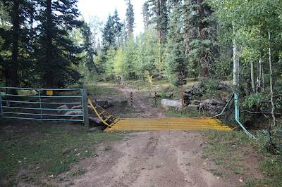
To get to the trailhead begin at the intersection of Townsend and Main in downtown Montrose. Head west following the signs for Highway 90. Continue following the Highway 90 signs for about 3.3 miles and turn left onto 6250 Road. After about 2.5 miles 6250 Road transitions to become the Dave Wood Road. Follow the Dave Wood Road for another 15.3 miles and turn right onto the Divide Road. Continue on the Divide Road for 1.3 miles where the sign in this picture will be on the left hand side of the road.
For this post we parked at the lower trailhead and then followed the Divide Road for 2.5 miles to the upper trailhead and picked up the trail from there.There is a trail squeeze that limits use to ATV's no wider than 50 inches.
From the trailhead the double track starts out with a gentle climb.
There are a few stretches where the trail gets a little rocky and others where an abundance of tree roots make it somewhat bouncy.
For the most part though the trail is smooth and fast flowing.
And down right pleasant.
Where the trail travels along the rim there are two overlooks called the 'Little Rock Pile' and the 'Big Rock Pile'. This is a picture of the big one.
In this photo taken from one of the overlooks you can see the Wilson Group of 14ers southwest of Telluride with Lizard Head sticking up off to the left. The areas above 12,000 feet received a fresh coat of snow overnight.
From the overlooks the trail is mostly downhill. There are some more rocky sections but if you are going in this direction they are easier to handle. We felt the rocky sections of trail were enough to include an intermediate mountain bike skill level to the otherwise easy rating for the rest of the trail.
Looking at the elevation profile for the trail shows that going in this direction there is a gradual climb for the first 3 miles or so followed by the downhill stretch back to the trailhead. The profile doesn't include the uphill stretch on the Divide Road but that part is also gradual.
The Rim Trail #116 gets regular use from ATV's, dirt bikes, mountain bikes and riders on horseback as well as a few hikers. (There is another Rim trail on the north end of the Uncompahgre Plateau so we are including the trail number to differentiate the two.) When we were taking the photos for this post we saw all of the above including three women that were on a 'hut to hut' mountain bike ride. We also saw a few elk tracks that were made sometime after it had quit raining the night before as well as some wild turkeys. The wild turkey population on the Uncompahgre Plateau seems to be exploding in recent years. For those that are looking for a nice multi-use trail in a forest environment or just a good place to go for a hike the Rim trail is a nice option to keep in mind. If you would like to see it for yourself then all you have to do is grab your favorite toy or 'Take a hike'.


