


Round Trip Distance: 3 miles
Difficulty: Moderate
Elevation: 6528 - 6933 feet
Cellphone: 0 bars
Time: 1 hr. 45 mins.
Trailhead: Long Park Rd. (EE22) MM 6
Fee: none
Attractions: Paradox Valley Overlook
The Long Park trail is located west of Highway 141 between Naturita and Gateway, Colorado. The trail begins off of the Long Park Road, a.k.a EE22 Road, where it follows old mining roads up to a ridge that overlooks the Paradox Valley. Along the way the trail passes near several abandoned mining sites.

To get to EE22 Road head south from Gateway, Colorado on Highway 141 for 35.5 miles. If coming from Naturita the turnoff comes up after 15 miles. From the highway follow the road as it crosses a bridge over the San Miguel River and begins climbing steeply along the hillside. At the top of the hill the road levels off as it passes between several reclamation sites from the uranium industry.

After passing between the reclamation sites an intersection comes up where the U16 Road branches off on the right. As EE22 continues within a little less than a half mile it passes the point where the V16 road branches off on the right leading to some communication towers on top of a nearby hill. EE22 bends around the hill and at the 4.4 mile point from the highway the W16 Road branches off on the right. About 3/4 of a mile past that is another intersection where the W15 Road connects on the right. From there it is just under 1 mile to the unmarked intersection in this picture where an old mining road begins. The GPS coordinates for this remote location are 38.32534, -108.79347. We recommend a high clearance vehicle but a careful driver in something less could probably make it under dry conditions and especially if the road has been recently graded. The surface of the road gets really slick when it is wet.

There aren't any trail markers or a sign designating a trailhead for this trail. We read about it on the West End Trails Alliance website after having purchased one of their maps at the Naturita Information Center. We had downloaded their GPX file and used it to find the trail and follow their suggested course. After parking off to the side at the intersection we began hiking up the mining road.

The mining road is suitable for most any type of OHV or high clearance 4x4 vehicle.

Just past the quarter mile point there are a couple of spurs that branch off on the left while the main route keeps to the right. This is where having a GPS with the trail loaded in it can come in real handy.

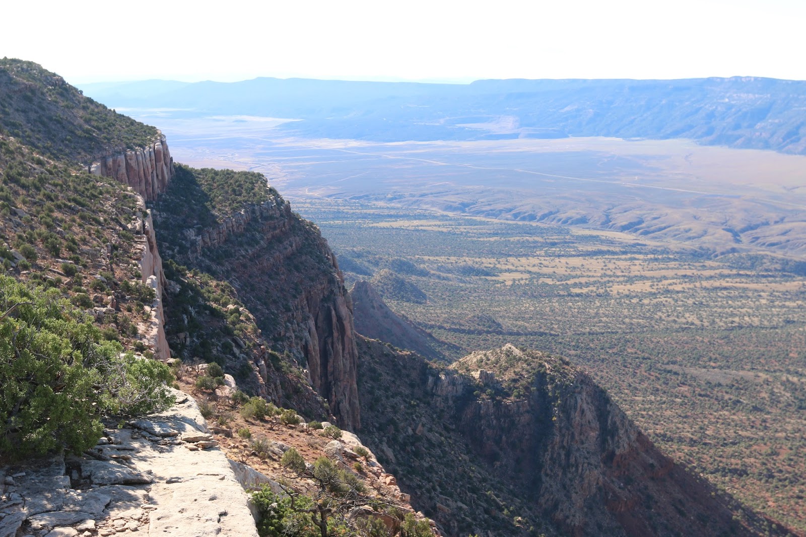
There are many more places where trails branch off on both sides of the road. For most of them it is obvious that they don't lead toward the ridge or appear to be as established as the main road. The exception is just under the 1 mile point where the main route turns to the right while the road to the left leads past a weather station that sits in the trees off to the side. At this point there is a short side trail that leads to an overlook near the weather station.

From here the Paradox Valley can be seen stretching below to the left and to the right with the town of Bedrock, Colorado right in the middle. The town of Paradox is further up the valley to the right just outside of view in this photo.

The Paradox Valley gets is name because of the long valley that has the Dolores River cutting across it rather than running the length of it.

There is also a nice view of the southeast side of the La Sal Mountains just across the border in Utah.
The road continues along the rim until it comes to an end at an abandoned mine site. We strongly recommend turning around at this point and retracing the route back to the EE22 Road. The write up on the West End Trails Alliance website suggests continuing to hike along the ridge and then cutting cross country through the trees and looping back that way. We tried it and it was pretty miserable trying to pick out a suitable route and that was with the aid of their GPS file. If you use our GPS file for that part of the hike it won't be any more pleasant. You will want to wear sturdy boots and long sleeves and pants and expect to fight your way through a lot of brush. That said, there are some more very nice views while hiking along the rim if you decide to explore it a little further.

